|
"Southampton is one of the most intemperate towns in England!" Mr Joseph Chamberlain, M.P. Printers were notoriously heavy drinkers and, in many places, employed a dedicated pot boy to fetch the liquor of choice. Although drunkenness obviously interfered with typesetting and the operation of heavy machinery, alcohol was considered an antidote to lead poisoning and beer a suitable expense to draw down from a printing chapel’s income (Greenwood, 2015: 75). It was also embedded in the trade’s culture of sociability: lubricating meetings, underpinning trade rituals, and accompanying celebrations. Historian Phil Withington (2007) comments that “sociability was the flux which made the whole system work,” and Clive Behagg (1982) has described the workplace and the pub as “twin streams feeding the same collective values and beliefs” (157). Throughout the nineteenth century, you may not have wanted to drink the water, and sanitation was certainly top of the civic agenda in Southampton as elsewhere, but it was difficult to avoid the ubiquity of public-houses, alehouses and breweries. As printer Charles Timperley remarked, it was like running the gauntlet to work every single day. 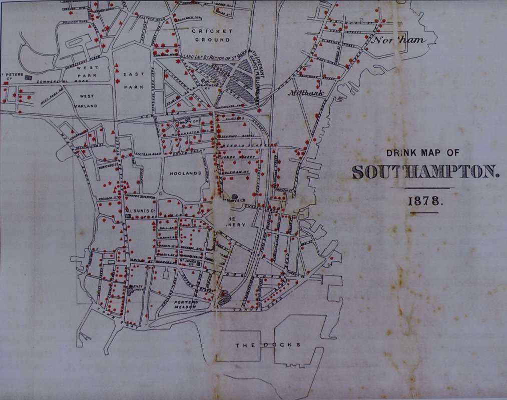 In 1878, Canon Basil Wilberforce, grandson of the famous abolitionist William, issued this Southampton Drink Map on behalf of his St Mary’s Church of England Temperance Society. Handed out to disembarking sailors, the gesture backfired royally. The map highlighted the teetotal zone in Wilberforce’s parish, but it more clearly identified all the local drinking establishments: 522 in the space of eight square miles. In effect, it ended up being the best kind of Lonely Planet Guide for parched sailors swaying to the tune of disposable income (Campbell). And, like much ephemera from the time, it was read almost to death; only one copy remains in the Tudor House Museum, Southampton City Archives. Southampton joined drink maps issued by temperance movements in Birmingham (1877) and Norwich (1878), and preceded those of York (1882), Newcastle (1883), Liverpool (1883), Glasgow, (1884), London (1884), and Manchester (1889). Moreover, in a new era of spatial mapping of diseases like cholera and typhus, the density of red spots made towns appear as though they were infected with scarlet fever (Beckingham, Hyde, Brown).
For one of our digital narratives, we will overlay the Drink Map with printers’ places of work and residences and analyse the topography of the trade. We will identify the associational cultures that pitted non-conformist abstainers against conservative, establishment industrialists, convivial masculinity against manly respectability (Greenwood, 89). And, we will demonstrate the ways in which the temperance movement infiltrated the ranks of printers and the allied trades - sometimes in unexpected and surprising ways. References Beckingham, David, “Mapping Drink: Temperance and the spatial logic of social reform,” in The Licensed City: Regulating drink in Liverpool 1830-1920. Liverpool University Press, 2017. Behagg, Clive, “Secrecy, Ritual and Folk Violence: The Opacity of the Workplace in the First Half of the Nineteenth Century,” in Popular Culture and Custom in Nineteenth-Century England, ed. by Robert D. Storch. London: Croom Helm, 1982: 154–79. Brown, J.R. "Landscape of Drink: Inns, Taverns and Alehouses in Early Modern Southampton." PhD Thesis, Warwick U, 2007. Campbell, George, "The Drink Map of Southampton," Hampshire Field Club and Archaeological Society, Newsletter 48 (Autumn 2007): 20-22. Greenwood, Emma L. “Work, Identity and Letterpress Printers in Britain, 1750-1850.” PhD thesis, U of Manchester, 2015. Hyde, R. “Cartographers versus the Demon Drink,” Map Collector 3 (1978): 22-27. Withington, Phil, 'Company and Sociability in Early Modern England', Social History, 32:3 (2007): 291–307.
0 Comments
|
AuthorSydney Shep, Reader in Book History & The Printer, Wai-te-ata Press, Victoria University of Wellington, NZ ArchivesCategories |
 RSS Feed
